Sunday, June 28, 2009

Un sistema de captación de agua de lluvia

What is rainwater harvesting and is it really worth it?

Rainwater harvesting is any form of collecting rainwater from a surface. It has been used by civilizations all over the world for centuries. Traditionally rainwater harvesting has been used as a method to provide more water for irrigation purposes. Now however, many people are looking to rainwater harvesting as a great method of conservation. Across the US, cities and states are looking at building codes and water restrictions in order to update the
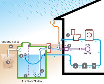
m to allow rainwater harvesting. At this time though, most places in the US prohibit it (except as a farming technique) and others that allow it only permit the water to be used for non potable use (toilet flushing, irrigation, car washing...). The two most progressive cities in the US right now for this upcoming technology are Portland, OR and Austin, TX.

Here in the Dominican Republic I am designing a rainwater harvesting system for the Punta Cana Resort and Club. This system and report will show how much water is available to harvest, based on roof size, roof material, and average rainfall. It will also show an estimated cost for the system. In the US, there is a "return" factor based on water price and electricity that dictates whether the system will repay itself over time. Here, this resort has several wells that provide the water so they do not pay a water tariff. They will save money however, because they will use less electricity pumping water from the water treatment plant. One of the main concerns on this primarily coastal country is the limited freshwater aquifers. Especially on the coast, saltwater may infiltrate the freshwater table in a matter of years if water is not conserved. The resort is very receptive of conservation possibilities. Unfortunately, many other resorts are not so interested. Hopefully, they will soon find that preserving the environment is really preserving the toursim industry and the economy of this beautiful country.

Thursday, June 25, 2009

Mysterious Water

Wednesday, June 24th, Steph, Tammy, Erika (volunteer from Oberlin), and I had a journey into the town of Blacksburg for an early morning full of GPS collection. We had a lot of uncovered ground in which to collect points - the high school and a lot of recreational fields. This involved a lot of wandering and zig-zagging around the fields and on the running track. Luckily school is out of session, so only the few driving by had the priviledge of thinking we were delusional. Two known springs feed into Stroubles Creek, one of which we had previously found. This spring has been funneled into a central "spout" that is under a tunnel by the apartment complex Erika lives in. The other spring has been a little harder to identify. We believe that it might be covered up by a bunch of rocks in a separate apartment complex. But, we are unsure of this, for it might be simple groundwater flowing out of this area where we think the spring might exist. This means that the spring is actually further downstream from this area of mysterious flow we have found, and the construction at the apartment complex has actually extended the delineation of the creek due to storm water management and/or daylighting potential groundwater flow. We need to go back out with waders to access parts of the stream we were unable to on this adventure. The exciting part of this adventure (besides playing on the multiple playgrounds and picking blackberries) was a third spring we have discovered. This is a known spring, but most people have not connected this spring with supplying water to Stroubles Creek. Again, when we can go back out with waders we will be able to further investigate this spring, but for now, we believe this spring might feed into Stroubles Creek, and it is the supply of water from this spring that actually feeds the daylighted section of Stroubles by the fire house.

Tuesday, June 23, 2009

Greetings from the Dominican Republic

My name is Caitlin Grady and I am a rising senior at Virginia Tech. I have been working in the Virginia Water Resources Research Center since April 2008 and this summer I have the pleasure of working through an NSF REU grant, under Dr. Tamim Younos, on a project in the Dominican Republic. This project is to analyze and prepare a cost benefit analysis as well as a design for a rainwater harvesting system at the Punta Cana Ecological Foundation, which is a part of the Punta Cana Resort and Club. This project will evaluate water consumption and potential water harvest from rainwater while also looking into design components and cost of construction. I am currently in Punta Cana, Dominican Republic collecting information about water use and roof type as well as current plumbing constraints and how this system could be implemented. This could, in the future, become a model to resorts in the area on how to conserve and re-use water.

About Me

Hello World. Tiffany Sprague here. I am going into my sixth year at James Madison University in Harrisonburg, VA. This summer I am conducting research at Virginia Tech under a NSF REU Grant. Tamim Younos, PhD is my main advisor, while graduate student in the Geography Department, Tammy Parece, oversees my project. The goal of my research here is to pair with Steph to conduct a longitudinal study on the Upper Stroubles Creek Watershed. This watershed has been highly affected by urbanization on the Virginia Tech campus and the downtown section of Blacksburg. Urbanization has resulted in construction related elevation changes, covering long segments of the creek (for example, Stroubles actually runs underneath the Drillfield on campus), and storm water management related changes, such as storm drains that carry water to other watersheds. Thus, the main focus of my project will be to take GPS readings throughout the town to delineate a field-derived Digitial Elevation Model (DEM), and compare my DEM with those that have been generated from old topographic maps and present day satellite imagery. I will also analyze land use changes over time in the "original delination" of the Upper Stroubles Creek Watershed using aerial photography that dates back to the 1930s. Therefore, through the use of GIS and Remote Sensing, I hope to gain a better understanding of the impacts urbanization has on the Upper Stroubles Creek Watershed, and what this means for the future of this creek.

Sunday, June 21, 2009

Introduction

Hi, my name is Stephanie DiBetitto and I am an undergraduate at the University of Vermont.  This summer I am doing research under Dr. Tamim Younos, and being advised by Tammy Parece.  My research includes a longitudinal analysis of the Upper Stroubles Creek Watershed.  I will be examining the physical, chemical and biological changes in the watershed due to urbanization over time.  I mostly do literature review to find historical data on Stroubles Creek, along with raw data of research already done.  By compiling all that is known about these changes I will be able to accurately determine the overall effects of urbanization on a watershed overtime.  My research also includes GPS, GIS, map and aerial photography data interpretation.  

Welcome

Hello and welcome to the Virginia Water Resources Research Center Undergraduate Research Blog! This blog has been created in order to document the research efforts of the VWRRC and the undergraduate students who are committed to learning through research. This summer, three undergraduate researchers will be documenting projects constructed by Dr. Tamim Younos under the NSF REU grant program. A few other researchers and professors may also comment and post on this site throughout the summer and the upcoming year. Welcome to our blog! Enjoy!